GINTEC G40 AR Base Rover GNSS Receiver Kit Incl. Internal UHF-GSM Modem With Controller GINTEC G40-KIT
Overview
GINTEC G40 AR GNSS receiver with revolutionary vision technology. Experience real-time visual layout, eliminating repetitive pole adjustments. Our professional-grade camera ensures clear vis...
Categories
Cart
Account
Search
Recent View
Go to Top
All Categories
×
- Equipment Spares
- Hand Tools
- Hand Tools & Accessories
- Intelligent Locks
-
Material Testing
- Aggregate And Chippings
- Bitumen Extraction : Extractor Bottle Method (BS 598)
- Bitumen Extraction : Hot Extractor Method (BS 598)
- Bitumen Spray Test (BS 1707)
- CBR (AASHTO T193)
- Concrete: Cube Compression Testing
- Concrete: Slump And Cube Manufacture (BS 1881)
- Consumables
- Density - Nuclear Density Method (AASHTO T238)
- Density - Sand Replacement Method (BS1377)
- Flakiness (BS 812)
- General Equipment
- Marshall Test (ASTM D1570)
- Miscellaneous Equipment
- Relative Density Of Aggregates (BS 812)
- Sieve Analysis (BS 1377)
- Standard Specifications (Latest Editions)
-
Measuring Tools
- Air Quality & Particle Meters
- Air Velocity & Manometers
- Calipers & Micrometers
- Fiberoptic Scopes & Boroscopes
- Force, Torque & Vibration Meters
- Gas, Leak & Radiation Detectors
- Hardness, Thickness & Gloss Meters
- Home Inspection Kits
- Hydrometers
- Insulation, Resistance & Capacitance Testers
- Light, Sound, Moisture & Environmental Meters
- Multimeters, Clamp Meters & Electrical Testers
- PH, Conductivity & TDS Meters
- Pressure Gauge
- Refractometers & Heat Stress Meters
- Soil Fertility Meters
- Tachometers & Stroboscopes
- Test Meter Calibration Kits
- Thermal Imagers & Infrared Thermometers
- Thermo-Hygrometers & Psychrometers
- Thermocouples & Digital Thermometers
- Weighing Scales
- Measuring Tools Accessories
- Medical Equipment
- Metal Detectors
- NDT Test Equipment
-
Power Tools
- Blowers
- Circular Saws
- Cutters
- Demolition Hammers
- Drill Drivers
- Dust Extractors
- Grinders
- Heat Guns
- High Pressure Washers
- Impact Drills
- Impact Wrench
- Jig Saws
- Light
- Mitre Saws
- Multi-Cut Saw
- Nibblers
- Planers
- Polishers
- Rotary drills
- Rotary hammers
- Routers
- Sabre Saws
- Sanders
- Table Saws
- Vacuum Cleaners
- Vibrators
- Wall chasers
-
Power Tools Accessories
- Batteries & Starter Kits
- Best Diamond wet core cutter
- Chisels
- Cloth hand sanding roll
- Color foam blocks
- CYL 3 Concrete Cylindrical Drill Bits
- CYL-9 Cylindrical Drill Bits
- CYL-9 Multi Construction Cylindrical Drill Bits
- CYL-9 Natural Stone Cylindrical Drill Bits
- Diamond drill bits
- ECO Circular saw blade
- ECO Diamond cutting disc
- Expert Circular saw blade
- Expert Cutting/grinding discs
- Expert Diamond cutting disc
- Fibre-Sanding Discs
- Flap discs
- Grinding wheels
- Hand sanding sheets
- Holesaw sets
- HSS bi-metal holesaws
- HSS PointTeQ Metal drill bits
- HSS-Co Metal drill bits
- HSS-G Metal drill bits
- Jigsaw blades
- Multi-cutter Accessories
- Polishing pad (for GPO)
- Power Tools Accessories
- Probox HSS Metal drill bits
- Professional Diamond cutting disc
- Progressor holesaws
- Routing bits
- Sabre saw blades
- Sanding belts
- Sanding sheets
- Screwdriver bits
- Screwdriver bits set
- SDS-max-4 drill bits
- SDS-max-7 drill bits
- SDS-max-9 drill bits
- SDS-plus adapters holesaws
- SDS-plus-1 drill bits
- SDS-plus-5 drill bits
- Self Cut Speed spade Wood Drill Bits
- Sheet metal holesaws
- Sockets
- Standard brad point Wood Drill Bits
- Standard Circular saw blade
- Standard Cutting/grinding discs
- Standard Diamond cutting disc
- Standard Diamond grinding head
- Wood auger drill bits
-
Survey Accessories
- Batteries & Chargers
- Bipods & Tripods
- Calculators
- Drafting Supplies
- Field Cases
- Flash Cards & USB
- Glasses, Wall Mounts & Accessories
- GNSS Accessories
- Instrument Tripods
- Lasers & Leveling Rods
- Power, Antennae & Data Cables
- Prism Pole & Rod Accessories
- Prism Poles
- Prisms & Assemblies
- Rover Rods
- Safety Clothes & Field Supplies
- Survey Accessories
- Tape Measures
- Tribrach & Adapters
- Vials & Levels
- Walkie Talkie Radios
-
Survey Equipment
- Car Navigation Systems
- Compass
- Detection Tools
- Distance measuring Tools
- Field Controllers
- GNSS Antennae
- GNSS External Radios
- GNSS Systems
- GPS Systems
- GPS Tracker
- Ground Penetrating Radar
- Indoor Navigation Systems
- Laser Levelling Tools
- Laser Receivers
- Optical Levelling Tools
- Softwares
- Theodolite
- Total Stations
- Water Detectors
- Wide Format Equipment
Shopping Cart
×
Your shopping cart is empty!
Search
×
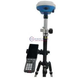


GINTEC G40 AR GNSS receiver with revolutionary vision technology. Experience real-time visual layout, eliminating repetitive pole adjustments. Our professional-grade camera ensures clear visibility even in challenging lighting conditions. Our fusion algorithm combines satellite and inertial navigation with visual perception, replacing outdated compass-based systems. Enjoy unparalleled accuracy without magnetic interference.
With 1408 channels, the G40 enhances fixed performance by an outstanding 20% even in obstructed environments. Upgraded with our GINTEC 5 satellites + 21 frequencies solution engine, the chip’s computational power is boosted by 40%, enabling precise calculations using a wider range of satellite frequencies.
New-Generation SoC: Powerful GNSS SoC chip with 1408 channels, Supporting the new B1C, B2a, B2b, and BeiDou-3
G-FIX supported: Calibration-Free Tilt Compensation, Calibration and initialization FREE, Ready for tilt survey straight out of the box
G-FIX Correction Outage Technology: Extending RTK positioning up to 10mins, Reducing downtime waiting to re-establish RTK corrections
Built-in Battery: Quick Charge, Supporting USB 3.0/45W quick charge, Charging time ≤ 3.5 Hours, Battery Life ≥ 2000 Circles
New Antenna Combination: Highly integrated GNSS,4G, WIFI, and Bluetooth antennas. Powerful Performance. Smaller Size
Anti-Interference Technology: Advanced multi-frequency interference suppression and multi-step adaptive filtering technology. Strong and stable signals in challenging conditions
Augmented Reality (AR): Overlaying digital information onto the real world. Assisting to view the stakeout location and see designed features in real time.
Professional Camera: High-resolution Night vision camera, Broad perspective, sophisticated algorithms guaranteeing the precision up to 1cm, Seamlessly combining 360-degree AR layout and image layout
G-FIX Correction Outage Technology: G-FIX Correction Outage Technology refers to the use of methods and techniques to mitigate the effects of GNSS correction data loss or outage, which is used to improve the accuracy of positioning by correcting errors caused by atmospheric and other environmental factors.
Brand-New Calibration and initialization FREE IMU: By utilizing a highly accurate Inertial Measurement Unit (IMU) and a unique tilt compensation function, RTK tilt measurement has been made practical. No calibration required, GINTEC G40 RTK is ready for precise measurement from the moment when it is turned on, allowing instant use. It is resistant to magnetic interference, making it suitable for use in any location. RTK measurement is no longer bound by bubbles, realizing an efficiency improvement of at least 30%, and greater measurement accuracy is guaranteed.
AR Stakeout: Use an AR tool to visualize the location and position of a design feature or structure on a real-world site. This involves using a GNSS receiver to locate the position of the design feature or structure on the site, and then overlaying an augmented reality image of the feature onto the real-world view. This process helps the surveyors to accurately stake out the location of the feature or structure and ensure that it is built according to the design specifications.
Package Details
With 1408 channels, the G40 enhances fixed performance by an outstanding 20% even in obstructed environments. Upgraded with our GINTEC 5 satellites + 21 frequencies solution engine, the chip’s computational power is boosted by 40%, enabling precise calculations using a wider range of satellite frequencies.
New-Generation SoC: Powerful GNSS SoC chip with 1408 channels, Supporting the new B1C, B2a, B2b, and BeiDou-3
G-FIX supported: Calibration-Free Tilt Compensation, Calibration and initialization FREE, Ready for tilt survey straight out of the box
G-FIX Correction Outage Technology: Extending RTK positioning up to 10mins, Reducing downtime waiting to re-establish RTK corrections
Built-in Battery: Quick Charge, Supporting USB 3.0/45W quick charge, Charging time ≤ 3.5 Hours, Battery Life ≥ 2000 Circles
New Antenna Combination: Highly integrated GNSS,4G, WIFI, and Bluetooth antennas. Powerful Performance. Smaller Size
Anti-Interference Technology: Advanced multi-frequency interference suppression and multi-step adaptive filtering technology. Strong and stable signals in challenging conditions
Augmented Reality (AR): Overlaying digital information onto the real world. Assisting to view the stakeout location and see designed features in real time.
Professional Camera: High-resolution Night vision camera, Broad perspective, sophisticated algorithms guaranteeing the precision up to 1cm, Seamlessly combining 360-degree AR layout and image layout
G-FIX Correction Outage Technology: G-FIX Correction Outage Technology refers to the use of methods and techniques to mitigate the effects of GNSS correction data loss or outage, which is used to improve the accuracy of positioning by correcting errors caused by atmospheric and other environmental factors.
Brand-New Calibration and initialization FREE IMU: By utilizing a highly accurate Inertial Measurement Unit (IMU) and a unique tilt compensation function, RTK tilt measurement has been made practical. No calibration required, GINTEC G40 RTK is ready for precise measurement from the moment when it is turned on, allowing instant use. It is resistant to magnetic interference, making it suitable for use in any location. RTK measurement is no longer bound by bubbles, realizing an efficiency improvement of at least 30%, and greater measurement accuracy is guaranteed.
AR Stakeout: Use an AR tool to visualize the location and position of a design feature or structure on a real-world site. This involves using a GNSS receiver to locate the position of the design feature or structure on the site, and then overlaying an augmented reality image of the feature onto the real-world view. This process helps the surveyors to accurately stake out the location of the feature or structure and ensure that it is built according to the design specifications.
- 1408 channels UM980 UNICORECOMM engine board
- GPS L1 C/A,L1C,L2P(Y),L2C,L5 GLONASS G1,G2,G3,
- BEIDOU B1L,B2L,B3L,B1C,B2a,B2b*
- GALILEO E1, E5a, E5b, E6/QZSS L1,L2C,L5
- Static Accuracy: H:±2.5mm+0.5ppm/V:±5.0mm+0.5ppm
- RTK Accuracy: H:±8.0mm+1ppm/V:±15.0mm+1ppm
- Operation System: Linux
- Memory: 32GB Internal Storage
- Bluetooth: V5.0, BLE & WIFI: 802.11a/b/g/n
- 4G Network: LTE FDD: B1/B2/B3/B4/B5/B7/B8/B12/B13/B19/B20/B25/B26/B28.LTE TDD: B38/B39/B40/B41.UMTS: B1/B2/B4/B5/B6/B8/B19. GSM: B2/B3/B5/B8
- Internal UHF Power: 1W with Frequency: 410~470MHz, 5-8km Distance Coverage
- Protocol: Gintec Work、TrimTalk450s(T)、TrimMark III、SOUTH、PCC-EOT、Hi-Target、GeoTalk、GeoMark, SATEL
- Tilt Survey: IMU Tilt Survey Compatible with SurPad
- Camera: 2Mega CMOS image sensor, & Optical Format: 1/5 inch,
- Pixel Size: 1.75um*1.75um & Active Pixel array: 1616*1232
- Built-in Battery, 9750mAh, 7.4V, ≥15hrs continuous operation
Package Details
- 2x GINTEC G40 AR GNSS Receiver Set
- 1x GINTEC P9IV Data Controller Incl. Surpad Software
- 1x G75003 Rotating Tribrach Adapter
- 1x G73007 Tribrach with optical plummet(Leica style), Green
- 1x G61102 Pole clamp+vial+compass
- 1x G61207 Quick Release cradles
- 1x G22000 Fiber Glass Round Head Tripod, Black
- 1x G61009 Snap-Lock Rover Rods 2m