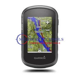
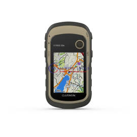
FeaturesColor Touchscreen GPS/GLONASS Handheld with Preloaded TOPO Maps
2.6-inch color capacitive touchscreen
3-axis tilt-compensated compass and barometric altimeter
GPS and GLONASS satellites for faster positioning
250,000 preloaded geocaches from Geocaching.com
Preloaded TOPO US 100K maps with extra internal memory to hold more maps
eTrex Touch 35t is a compact, rugged and reliable GPS/GLONASS handheld with color touchscreen, preloaded TOPO US 100K maps, dual GPS and GLONASS satellites positioning, 250,000 preloaded geocaches and wireless connectivity (ANT+®, VIRB® and smart notifications). With a 3-axis tilt-compensated electronic compass and barometric altimeter, you’re ready to navigate anywhere.
See the WayeTrex Touch 35t features a sunlight-readable, 2.6-inch color touchscreen display offering intuitive access to the preloaded TOPO US 100K maps. Durable and waterproof, eTrex Touch 35t is built to keep delivering vital mapping and tracking data no matter what the elements throw at you, standing strong against dust, dirt, humidity and water.
New Tools for Your TrekeTrex Touch 35t adds a built-in 3-axis tilt-compensated electronic compass that shows your heading even when you’re standing still, without holding it level. Also added is a barometric altimeter, which tracks changes in pressure to pinpoint your precise altitude, and you can even use it to plot barometric pressure over time, which can help you keep an eye on changing weather conditions.
Go AnywhereWith an array of compatible mounts, eTrex Touch 35t is designed for use on ATVs, bicycles, boats, as a handheld or in your car. Wherever you think you might take eTrex, it has the mapping and mounts to get you there.
Go GlobaleTrex Touch 35t can track both GPS and GLONASS satellites simultaneously. Developed by the Russian Federation, GLONASS satellites “lock on” to a position (on average) faster than GPS receivers. Using both GPS and GLONASS means the receiver has the ability to lock on to 24 more satellites than using GPS alone.
Add MapsWith its microSD™ card slot and an 8 GB internal memory, eTrex Touch 35t lets you load TOPO 24K maps and hit the trail, plug in BlueChart® g2 preloaded cards for a great day on the water or City Navigator® NT map data for turn-by-turn routing on roads. eTrex Touch 35t also supports BirdsEye Satellite Imagery (subscription required) that lets you download satellite images to your device and integrate them with your maps.
Stay ConnectedeTrex Touch 35t lets you share your waypoints, tracks, routes and geocaches wirelessly through unit-to-unit sharing to compatible Garmin devices. The smart notification feature means you’ll never miss a text, email or notification from your compatible smartphone*, unless you want to. You can even use your eTrex Touch 35t as a remote control for our action cameras.
Find FuneTrex Touch 35t is preloaded with 250,000 geocaches from Geocaching.com. By going paperless, you're not only helping the environment, but also improving efficiency. eTrex Touch 35t stores and displays key information, including location, terrain, difficulty, hints and descriptions, which means no more manually entering coordinates and paper printouts. Simply upload the GPX file to your unit and start hunting for geocaches.
Plan Your Next TripTake charge of your next adventure with BaseCamp™, software that lets you view and organize maps, waypoints, routes and tracks. This free trip-planning software even allows you to create Garmin Adventures that you can share with friends, family or fellow explorers. BaseCamp displays topographic map data in 2-D or 3-D on your computer screen, including contour lines and elevation profiles. It also can transfer an unlimited amount of satellite images to your device when paired with a BirdsEye Satellite Imagery subscription.
*Phone must be Bluetooth Smart. See Garmin.com/BLE for compatibility.
iPhone is a trademark of Apple Inc. Android is a trademark of Google Inc.
Physical & Performance
- Physical dimensions: 2.3” x 4.0” x 1.3” (5.8 x 10.2 x 3.3 cm)
- Display size, WxH: 1.43" x 2.15" (3.6 x 5.5 cm)
- Display resolution, WxH: 160 x 240 pixels
- Display type: 2.6" 65K color TFT
- Touchscreen: Yes
- Weight: 5.6 oz (159 g) with batteries
- Battery: 2 AA batteries (not included); NiMH or Lithium recommended
- Battery life: Up to 16 hours
- Water rating: IPX7
- High-sensitivity receiver: Yes
- Interface: USB
- Barometric altimeter: Yes
- Electronic compass: Yes
- Unit-to-unit transfer (shares data wirelessly with similar units): Yes
Maps & Memory
- Basemap: Yes
- Preloaded maps: yes (topographic)
- Ability to add maps: Yes
- Built-in memory: 8GB
- Accepts data cards: Yes
- microSD™ card (not included): yes
- Custom POIs (ability to add additional points of interest): yes
- Waypoints/favorites/locations: 4000
- Routes: 200
- Track log: 10,000 points, 200 saved tracks
Outdoor Features
- Automatic routing (turn by turn routing on roads): Yes (with optional mapping for detailed roads)
- Geocaching-friendly: Yes (Paperless)
- Custom maps compatible: Yes
- Sun and moon information: Yes
- Tide tables: Yes (with optional Bluechart)
- Area calculation: Yes
- Picture viewer: Yes
- Garmin Connect™: Garmin Connect™ compatible (online community where you analyze, categorize and share data)
- Smart Notifications: yes
- Live Tracking: yes (with Garmin Connect™ Mobile)
Contents Of The Package
- eTrex Touch 35
- USB cable
- Documentation